Spedizione articoli
29,15 € *
Prezzi incl. 4% IVA più spese di spedizione
Pronto per la spedizione di oggi,
tempo di consegna ca. 1-3 giorni **
- Numero Ordine: AS01884
- Publisher: Absolutezero
- Lingua: English
Base cartography is the US Road-Atlas 1: 2.000.000 which includes mountain ranges, lakes, rivers... altro
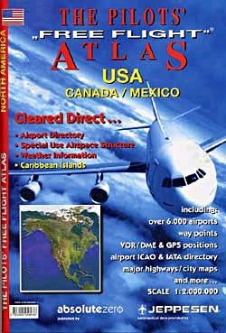
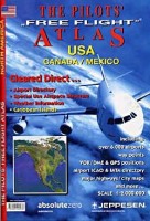
Informazione prodotto "The Pilots Free Flight Atlas - USA, Canada, Mexico"
Base cartography is the US Road-Atlas 1: 2.000.000 which includes mountain ranges, lakes, rivers and more. As well, all other elements such as, cities, towns. Parks and points of interest or historic value and of course, the railways and motor-ways themselves.
To this, we have added all airports in USA (over 5,500) and colour coded them by runway length/surface and category (ie. International, Regional, Civil/Military), VOR/DME, Reporting points, Waypoints, Volmet frequencies and special Use Airspace are also shown making our new "Pilots' Atlas" the first of it’s kind.
Included:
- Coverage: USA, South Canada, Mexico, Caribic and Virgin Islands
- Maps: 104 Pages, Scale 1:2.000.000
- Citymaps: 30 pages City maps, Scale 1:20.000
- Captains Corner: 46 pages
Features:
- Elevation by color - Colored tints provide generalized terrain elevations
- Weather stations frequencies (VOLMET) are shown on each page for easy use; ATIS frequencies are found in the airport directory in the Captain's Corner
- VOR/DMEs, NDB's are included so that you are able to locate your position immediately in relation to surrounding airports, landmarks and points of interest
- All airports large and small are included with 4-letter ICAO-codes and have been color coded by runway length / surface and airfield type
- Glider field positions in North America are shown by a special sign for easy identification
- Over 3,500 points of interest for better passenger announcements, including geographical, cultural and historical information
- Highways, railways and landroads are indicated
- Also included are lakes, rivers and mountain ranges depicted in color
- 11 city maps of the most important cities in USA are depicted as well
Link correlati a "The Pilots Free Flight Atlas - USA, Canada, Mexico"
-10
-30
-30
NUOVO
NUOVO
NUOVO
NUOVO


.jpg)
.jpg)
.jpg)
.jpg)
.jpg)
.jpg)
.jpg)
.jpg)
.jpg)
.jpg)
.jpg)
