Precio incl. 21% IVA legal
Disponible como descarga inmediata
- N.º artículo: AS14302
- Fabricante: PC Aviator
- Idioma: English
- Versión actual: 3.00
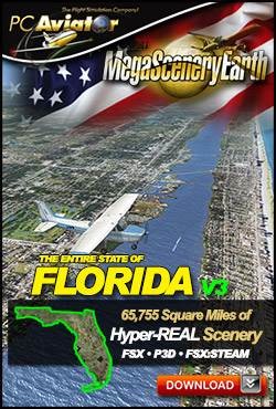
The New MegaSceneryEarth 3 - Florida featuring unsurpassed image sharpness, scenery color and clarity, improved scenery features with accurate additional water bodies and topographical data and the latest aerial imagery.
Fly the entire state - BORDER to BORDER - of The Sunshine State - Florida in photoreal detail. Florida is 65,755 square miles in size and has 593 airports. You'll see everything that you see in Florida in real life in the scenery.
As an added bonus, we now provide all the VFR and IFR charts in digital PDF format to enable you to get the most out of your scenery. This includes Sectionals, IFR enroute charts and 785 page book of Instrument Approach plates, Airport Diagrams, SIDs and STARs, and an Airport Facility Directory. The charts are downloadable along with your scenery files.
Some of the cities and landmarks you'll get to enjoy as you explore Florida include:
- Cities: Miami, Jacksonville, Tampa, Saint Petersburg, Hialeah, Orlando, Fort Lauderdale, Tallahassee
- Lakes & Water Bodies: Lake Okeechobee, Lake George, Lake Apopka, Lake Kissimmee, Tampa Bay, Charlotte Harbor, Biscayne Bay, 1800 miles of coastal Gulf of Mexico and Atlantic Ocean shoreline including the Florida Keys
- Mountains & Hills: N/A, Florida is extremely flat with an average elevation of 100 ft
- State Parks & National Forests: Osceola, Apalachicola, Ocala, Big Cypress, The Everglades and dozens of state forests
- Major Rivers: St Johns, Withlacoochee, St Mary's, Suwanee, Apalachicola. 50,000 miles of rivers in total
Discover the rest of it all for yourself! There's so much to see in Florida!
Set of FAA Aeronautical Charts for Florida:
- Sectional Charts: Miami, Jacksonville, & New Orleans
- Terminal Area Charts: Miami, Orlando, Tampa
- VFR Flyways Planning Charts: Miami & Orlando
- Low Altitude IFR Charts: ELUS-21/ELUS-22 & ELUS-23/ELUS-24
- High Altitude IFR Charts: EHUS-07/EHUS-08
- Airport Facility Directory: A fully indexed 85 page PDF booklet
- Approach Charts & Airport Diagrams: A fully indexed 785 page PDF booklet
Please use this link for download instructions.
Microsoft Flight Simulator X (SP2 or Acceleration), FSX: Steam Edition or Prepar3D (V1-V4)
Windows 8 / 7 / Vista / XP (32 bit and 64 bit)
Download-Size: 47 GB


